
-
-
-
Seafloor Planner 2.6: What’s New?
Support for coordinate reference systems using feet Periodic reports: Export statistics at selected intervals over the survey plan Optionally handle receivers in full lines, in rolling spread surveys Bug fixes and usability improvements
-
Seafloor Planner 2.5: What’s New?
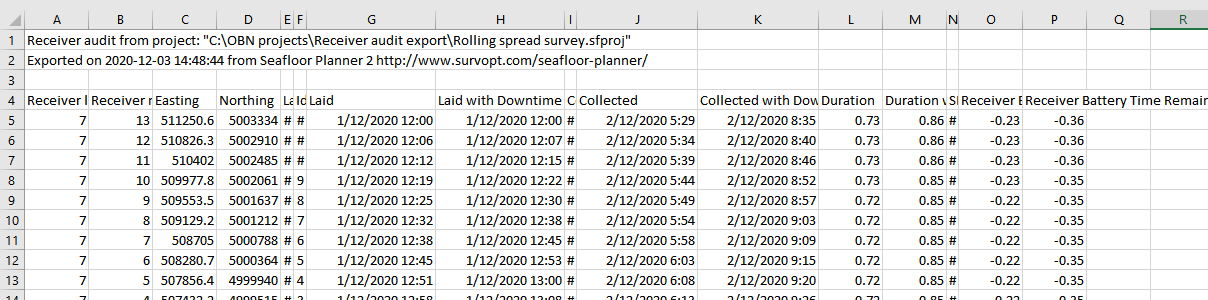
Receiver and source area polygons can now be loaded from shapefiles New receiver points CSV export available Bug fixes and usability improvements
-
Seafloor Planner 2.4: What’s New?
Lay ahead by number of patches CSV export improvements Bug fixes and usability improvements
-
Seafloor Planner 2.3: What’s New?
Export receiver and shot tasks to CSV New properties for multirole vessels Import a source area from a polygon New progress bar while survey is building New method of calculating polygon area Bug fixes and usability improvements
-
Seafloor Planner 2.2: What’s New?
Enforce a minimum separation between source vessels Optimize a survey within user-defined tiles New Alerts display panel Smarter interpretation of SPS files Bug fixes and usability improvements
-
Seafloor Planner 2.1: What’s New?
Important note on release 2.1: Source line generation changes for dual-source shooting Multirole vessels New/extended coordinate reference system capability Background images Set max line length for patch optimization Turn pattern optimization Bug fixes and usability improvements
-
Seafloor Planner 2.0.2: What’s New?
Obstructions that vessels can enter Specify number of tiles (zippers) in main survey dialog Display origin, inline / crossline axis and distance grid Bug fixes and usability improvements
-
Seafloor Planner 2.0.1: What’s New?
Important notes on release 2.0.1 Improved receiver lay ahead options Improved source line patterns Export patches to SPS format Bug fixes and usability improvements